Grades 7-8,
Grades 9-10,
Grades 11-12
November 15, 2025
Registration deadline
November 13, 2025
December 20, 2025
Registration deadline
December 18, 2025
March 24-30, 2026
Registration deadline
February 1, 2026
50 Q Preliminary
35+2 Q Global Final
75 min Preliminary
120+120 min Global Final
English, Russian,
French, and Spanish
MECHANICS
Brainiacs Geography Olympiad Mechanics
The Brainiacs Geography Olympiad is a globally renowned competition aimed at encouraging creativity, innovation, and academic excellence in students from Grade 7 to Grade 12. The Olympiad is structured into two main stages: the Preliminary Round and the Global Round.
PRELIMINARY ROUND
Registration
Students can register for the Olympiad through the official Brainiacs Olympiad website or via authorized representatives in their respective countries.
Dates
The online qualifying exams for the Preliminary Round are scheduled for:
- Online I: November 15, 2025 (Registration deadline: November 14, 2025)
- Online I Results: November 20, 2025
- Online II: December 20, 2025 (Registration deadline: December 19, 2025)
- Online II Results: December 25, 2025
The two online rounds are the same, but feature different questions. Those who did not qualify for the global round in the first online round, along with those who were absent from the first round, can participate in the second round.
Format
The exam consists of 50 questions divided into three levels of difficulty:
- Easy: 15 questions
- Normal: 20 questions
- Difficult: 15 questions
The exam consists of 50 multiple-choice questions to be completed within 75 minutes. Questions are tailored to the participant’s educational level and divided into the following categories:
- Category 1: Grades 7 and 8
- Category 2: Grades 9 and 10
- Category 3: Grades 11 and 12
Scoring
- Easy Questions: +1 for each correct answer
- Normal Questions: +2 points for each correct answer
- Difficult Questions: +3 points for each correct answer
- Incorrect Answer: No negative marking for any question
- Unanswered Questions: No points deducted
Qualification
Participants scoring at least 40% in the Preliminary Round qualify for the Global Round. Every participant receives a Certificate of Participation.
Recognition
In the Preliminary Round, medals are awarded based on the points earned by the participants:
- 40 to 49 : Honorable Mention Certificate
- 50 to 74 : Bronze Medal
- 75 to 89 : Silver Medal
- 90 to 100 : Gold Medal
GLOBAL ROUND
The Global Round is the final stage of the competition, where participants showcase their knowledge and ability.
Registration
Students can register for the Olympiad through the official Brainiacs Olympiad website or via authorized representatives in their respective countries.
Dates and Venue
Global Round of the 2nd Brainiacs Olympiad will take place in Xiamen University Malaysia from March 24 to 30, 2026.
- Standard Registration Deadline: February 1, 2026
- Late Registration Deadline: March 1, 2026
Exam Days
Global Round exam format is different from Preliminary Round. It has both Theoretical and Practical parts separated in two consecutive examination days.
Day 1. Theoretical Part
This is the traditional portion of a geography exam – it tests understanding of geographical concepts, reasoning, and analytical interpretation of maps, data, and texts.
Examples:
- Answering questions about physical and human geography (e.g., “What are the main factors that influence climate zones?”)
- Explaining geographical processes or patterns over time (e.g., urbanization, erosion, migration)
- Analyzing maps, diagrams, graphs, or written texts and drawing conclusions
- Short-answer or multiple-choice conceptual questions on location, spatial patterns, causes, and effects
Purpose:
To test geographical knowledge, critical thinking, interpretation of data and maps, and the ability to explain and connect processes, patterns, and interactions within local, regional, and global contexts.
Day 1. Exam Format
The exam consists of 35 questions divided into three levels of difficulty:
- Easy: 10 multiple-choice questions
- Normal: 10 multiple-choice questions
- Difficult: 10 multiple-choice questions
- Open-ended: 5 questions
The exam consists of 30 multiple-choice and 5 open-ended questions to be completed within 120 minutes.
Day 1. Exam Scoring
- Easy Questions: +1 points for each correct answer
- Normal Questions: +2 points for each correct answer
- Difficult Questions: +3 points for each correct answer
- Open-ended Questions: +8 points for full correct answer
- Incorrect Answer: No negative marking for any question
- Unanswered Question: No points deducted
Day 2. Practical Part
The practical part checks how students can apply geographical knowledge and analytical skills in real-world or investigative situations (using maps, data, or spatial evidence).
Examples:
- Interpreting physical, political, or thematic maps to identify patterns and relationships
- Analyzing geographic data such as climate graphs, population charts, or land-use maps to draw conclusions
- Conducting a short investigation on a geographic question
- Comparing different regions or environments to understand human–environment interactions
Purpose:
To test application of knowledge, spatial analysis, data interpretation, research, and the ability to use geographic evidence to explain real-world patterns and processes.
Day 2. Exam Format and Scoring
The exam consists of 2 tasks of 50 points each:
- Map-Based / Data Analysis Task (indoor)
- Fieldwork / Observational Task (outdoor)
Map-based tasks involve using, interpreting, or creating maps to understand spatial patterns, relationships, and geographical processes. They help students visualize the connection between places, environments, and human activity, turning abstract data into spatial understanding. Maps may be physical, political, topographic, climatic, economic, population, or thematic, depending on the topic studied.
Data analysis tasks require students to interpret, process, and evaluate geographical data to understand patterns, trends, and relationships in the physical or human environment.
These tasks may involve numerical, graphical, or visual data such as tables, charts, maps, or satellite images.
Fieldwork and observational tasks involve collecting, recording, and analyzing information directly from the environment — either outdoors (in the field) or virtually (through maps, videos, or satellite imagery). Students use observation, measurement, and recording techniques to investigate physical geographical features.
The exam is to be completed within 120 minutes.
Global Round Recognition
In the Global Round, medals are awarded based on the percentage distribution according to the number of participants.
- The top 10% (0-10%) of participants receive gold medals.
- The next 20% (11-30%) of participants receive silver medals.
- The next 30% (31-60%) of participants receive bronze medals.
- The next 15% (61-75%) receive honorable mentions.
Languages
All of the questions in Preliminary and Global Rounds will be in 4 languages: English, Russian, French, and Spanish.
SYLLABUS
INTRODUCTION TO GEOGRAPHY
- What is geography? Physical and Human geography
- Defining Physical Geography
- Scientific methods
MAP AND GLOBE AS A TOOL
- Maps. Using maps
- Map scale
- Cartographic symbols
- Orientation with a compass and a map
- The geographic grid
- Latitude, longitude. Using the geographic grid
- Isolines
- Global Positioning Systems (GPS)
- Geographic Information Systems (GIS)
EARTH AND SPACE
- Solar System. Planets of the Solar System
- Planet Earth (in space), the shape and size of Earth
- Earth’s Orbit around the Sun
- The Earth’s rotation and axial tilt
- The seasons, solstice and equinox
- Time zones and their types
- The Moon – the Earth’s satellite
THE EARTH’S FOUR SPHERES
- Atmosphere
- Hydrosphere
- Lithosphere
- Biosphere
ATMOSPHERE: GLOBAL TEMPERATURE PATTERNS
- Composition of the atmosphere
- Layered structure of the atmosphere
- Surface and air temperature
- The annual range of surface temperature
- Atmospheric pressure
- Atmospheric pressure systems
- The direction of airflow
- Atmospheric moisture and precipitation
- Physical properties of water: Thermal properties of water and its physical states
- The hydrosphere and hydrologic cycle
- Humidity: maximum, specific and relative humidity
- Evaporation
- Cloud formation and classification: Including Fog
- Precipitation: Types of precipitation, precipitation processes
- Air masses and fronts
- Cyclones and anticyclones
- Climate and the factors that affect it
- Climate zones
LITHOSPHERE, HYDROSPHERE AND EARTH’S INTERNAL STRUCTURE
- Earth’s inner structure: The major layers
- Rock and minerals in the Earth’s crust
- Plate tectonics. The lithospheric plates
- Types of plate movements
- Earthquake: Seismic processes
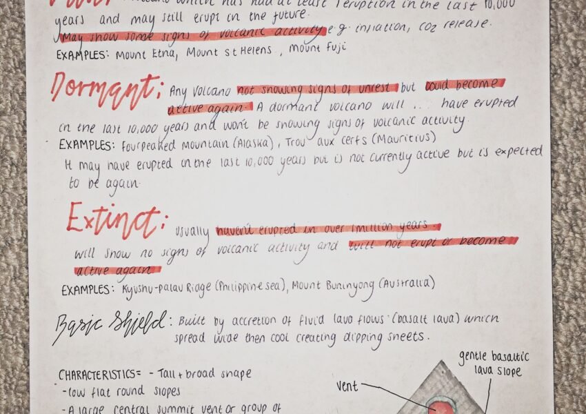
- Volcanoes
- Earth’s landforms (mountain ranges, plains)
- Movement and storage of groundwater
- Rivers and natural lakes
- Glacial geomorphology: Processes and landforms
- Development of a glacier
- Types of glaciers
- Glacial landforms
- Oceans and seas on Earth (straits and bays)
- Islands and peninsulas
- Regions, continents, their physical features and landscapes
BIOSPHERE. ECOLOGY AND ENVIRONMENT PROTECTION OF ECOSYSTEMS
- Biosphere as a science
- Ecosystems and their components. Biogeography
- Biomes and natural zones
- What is soil? Basic soil properties
- The relations of living organisms with other layers of Earth
- Parks, National Parks, Protected Areas
- Methods of preserving the natural environment
INTRODUCTION HUMAN GEOGRAPHY
- Defining Human Geography
- Population and settlements
- Population structure
- Migration and its types. Internal and international migration
- Urban settlements. Urbanization
- Economic geography and agriculture
- Labor resources and productive forces
- Energy, natural resources and their importance
- Transport and its types
NATURAL DISASTERS AND GLOBAL PROBLEMS
- Natural disasters and catastrophes
- Climate change and global warming
- Desertification, soil degradation
- Water scarcity and water conflicts
GEOGRAPHICAL SKILLS
- Reading maps and diagrams
- Determining distances by scale
- Working with climate diagrams
- Analyzing photographs, tables and graphs
- Fieldwork skills. Select and conduct appropriate fieldwork techniques
MAP AND GLOBE AS A TOOL
- Maps. Using maps
- Map projections
- Map scale
- Cartographic symbols and their types
- Orientation with a compass and a map
- The geographic grid
- Latitude, longitude. Using the geographic grid
- Isolines
- Global Positioning Systems (GPS)
- Geographic Information Systems (GIS)
EARTH AND SPACE
- Solar System. Planets of the Solar System
- Planet Earth (in space), the shape and size of Earth
- Earth’s Orbit around the Sun
- The Earth’s rotation and axial tilt
- The seasons, solstice and equinox
- The Moon – the Earth’s satellite
THE EARTH’S FOUR SPHERES:
- Atmosphere
- Hydrosphere
- Lithosphere
- Biosphere
ATMOSPHERE: GLOBAL TEMPERATURE PATTERNS
- Composition of the atmosphere
- Layered structure of the atmosphere
- Weather and meteorological phenomena
- Surface and air temperature
- Large-scale geographic factors that influence air temperature
- Surface and air temperature
- Large-scale geographic factors that influence air temperature
- Local factors that influence air temperature
- The annual range of surface temperature
- Atmospheric pressure
- Atmospheric pressure systems:
- Low pressure systems
- High pressure systems
- The direction of airflow
- Winds and their types
- Global pressure and atmospheric circulation:
- Tropical Circulation
- Midlatitude Circulation
- Polar Circulation
- Atmospheric moisture and precipitation
- Physical properties of water: Thermal properties of water and its physical states
- The hydrosphere and hydrologic cycle
- Humidity: maximum, specific and relative humidity
- Evaporation
- Cloud formation and classification: Including Fog
- Precipitation: Types of precipitation, precipitation processes
- Air masses and fronts
- Cyclones and anticyclones
- Evolution and character of midlatitude cyclones
- Tropical cyclones
- Climate and the factors that affect it
- Climate zones
- Global climate change
LITHOSPHERE, HYDROSPHERE AND EARTH’S INTERNAL STRUCTURE
- Earth’s inner structure: The major layers
- Rock and minerals in the Earth’s crust
- Plate tectonics. The lithospheric plates
- Types of plate movements
- Earthquake: Seismic processes
- Volcanoes
- Earth’s landforms (mountain ranges, plains)
- Groundwater and karst landscapes
- Movement and storage of groundwater
- Karst landforms and landscapes
- Fluvial systems and landforms
- Rivers and natural lakes
- Glacial geomorphology: Processes and landforms
- Development of a glacier
- Types of glaciers
- Glacial landforms
- Probable human impact on glaciers
- Coastal processes and landforms
- Oceans and seas on Earth (straits and bays)
- Islands and peninsulas
THE GLOBAL DISTRIBUTION AND CHARACTER OF SOIL
- What is soil? Basic soil properties
- Soil-forming processes and factors
BIOSPHERE. ECOLOGY AND ENVIRONMENT. PROTECTION OF ECOSYSTEMS
- Biosphere as a science
- Ecosystems and their components. Biogeography
- The relationship of climate and vegetation: the character and distribution of global biomes. Natural zones
- The relations of living organisms with other layers of Earth
- Human impact on ecosystems: air pollution, deforestation, urbanization
- Environmental risks of economic development
- Parks, National Parks, Protected Areas
- Methods of preserving the natural environment
REGIONS, CONTINENTS AND THEIR LANDFORMS, CLIMATE, NATURAL ZONES, LANDSCAPES, NATURAL RESOURCES, POPULATION AND ECONOMY
- Asia and Europe (Eurasia)
- Africa
- North and South America
- Australia
- Antarctica
- Countries and regions
TIME ZONES
- Time zones and their types.
- A geographic time zone
- An administrative time zone
- Coordinated Universal Time (UTC) and Greenwich Mean Time (GMT)
HUMAN GEOGRAPHY
- Human geography as a science
- Population and settlements
- Population dynamics
- Population structure
- Population density and distribution
- A densely and sparsely populated country or area
- Migration and its types. Internal and international migration
- Urban settlements. Urbanization
INDUSTRY AND ECONOMY
- Economic geography
- Economy. National economy and agriculture. World economy
- Industry. Light and heavy industry
- Types of industry: manufacturing, processing, assembly and high technology industry
- Labor resources and productive forces
- International division of labor and its types
- Developed and developing countries. HDI and GDP
- Energy, natural resources and their importance
SERVICE SECTORS
- Transport and its types
- Tourism and its types
GEOPOLITICS
- Conflicts and social problems
- International organizations and regional blocs
NATURAL DISASTERS AND GLOBAL PROBLEMS
- Natural disasters and catastrophes
- Types of natural disasters
- Climate change and global warming
- Desertification, soil degradation
- Water scarcity and water conflicts
- Energy security
- Global economic value
GEOGRAPHICAL SKILLS
- Skills of application, interpretation and analysis of geographical information: topographical map, other map, diagrams, graphs, tables of data, written material, photographs and pictorial material.
- Application of graphical and other techniques.
- GIS and image skills
- Fieldwork skills. Select and conduct appropriate fieldwork techniques
- Mathematical skills
MAP AND GLOBE AS A TOOL
- Maps. Using and analysis of the maps
- Map projections
- Map scale
- Cartographic symbols and their types
- Orientation with a compass and a map
- The geographic grid
- Latitude, longitude. Using the geographic grid
- Isolines
- Global Positioning Systems
- Geographic Information Systems
EARTH AND SPACE
- Solar System. Planets of the Solar System
- Planet Earth (in space), the shape and size of the Earth
- Earth’s Orbit around the Sun
- The Earth’s rotation and axial tilt
- The seasons, solstice and equinox
- The Moon – the Earth’s satellite
THE EARTH’S FOUR SPHERES:
- Atmosphere
- Hydrosphere
- Lithosphere
- Biosphere
ATMOSPHERE: GLOBAL TEMPERATURE PATTERNS
- Composition of the atmosphere
- Layered structure of the atmosphere
- Weather and meteorological phenomena
- Surface and air temperature
- Large-scale geographic factors that influence air temperature
- Local factors that influence air temperature
- The annual range of surface temperature
- Atmospheric pressure
- Atmospheric pressure systems:
- Low pressure systems
- High pressure systems
- The direction of airflow
- Global pressure and atmospheric circulation:
- Tropical Circulation – Hadley cell
- Midlatitude Circulation – Ferrel cell
- Polar Circulation – Polar cell
- Permanent, seasonal, daily and local winds
- Human interactions: Harnessing wind energy
- Atmospheric moisture and precipitation
- Physical properties of water: Thermal properties of water and its physical states
- The hydrosphere and hydrologic cycle
- Humidity: maximum, specific and relative humidity
- Evaporation
- Cloud formation and classification: Including Fog
- Precipitation: Types of precipitation, precipitation processes
- Air masses and fronts
- Cyclones and anticyclones
- Evolution and character of midlatitude cyclones
- Tropical cyclones
- Climate and the factors that affect it
- Climate zones
- Climate change and global warming
- Human interactions and future climate change
LITHOSPHERE, HYDROSPHERE AND EARTH’S INTERNAL STRUCTURE
- Earth’s inner structure: The major layers
- Rock and minerals in the Earth’s crust
- Human interactions with the Rock Cycle: The case of petroleum
- Plate tectonics. The lithospheric plates
- Types of plate movements
- Earthquake: Seismic processes
- Volcanoes
- Earth’s landforms (mountain ranges, plains)
- Groundwater and karst landscapes
- Movement and storage of groundwater
- Human interactions with groundwater
- Karst landforms and landscapes
- Fluvial systems and landforms
- Rivers and natural lakes
- Glacial geomorphology: Processes and landforms
- Development of a glacier
- Types of glaciers
- Glacial landforms
- Probable human impact on glaciers
- Coastal processes and landforms
- Oceans and seas on Earth (straits and bays)
- Islands and peninsulas
- The nature of coastlines: Interactions of Earth’s spheres
- Human interactions with coastlines
- Global climate change and the impact on coastlines
- The Global Distribution and Character of Soil
- What is soil? Basic soil properties
- Soil-forming processes and factors
BIOSPHERE. ECOLOGY AND ENVIRONMENT. PROTECTION OF ECOSYSTEMS
- Biosphere as a science
- Ecosystems and their components. Biogeography
- The relationship of climate and vegetation: the character and distribution of global biomes. Natural zones
- The relations of living organisms with other layers of Earth
- Human impact on ecosystems: air pollution, deforestation, urbanization
- Environmental risks of economic development
- Parks, National Parks, Protected Areas
- Methods of preserving the natural environment
REGIONS AND CONTINENTS AND THEIR LANDFORMS, CLIMATE, NATURAL ZONES, LANDSCAPES, NATURAL RESOURCES, POPULATION AND ECONOMY
- Asia and Europe (Eurasia)
- Africa
- North and South America
- Australia
- Antarctica
- Countries and regions
TIME ZONES
- Time zones and their types.
- A geographic time zone
- An administrative time zone
- Coordinated Universal Time (UTC) and Greenwich Mean
- Time (GMT)
HUMAN GEOGRAPHY
- Human geography as a science
- Population and settlements
- Population dynamics
- Population structure
- Population density and distribution
- A densely and sparsely populated country or area
- Migration and its types. Internal and international migration
- Urban settlements. Urbanization
INDUSTRY AND ECONOMY
- Economic geography
- Economy. National economy and agriculture. World economy
- Industry. Light and heavy industry
- Types of industry: manufacturing, processing, assembly and high technology industry
- Labor resources and productive forces
- International division of labor and its types
- Developed and developing countries. G7 countries
- Human development index (HDI) and Gross domestic product (GDP)
- Energy, natural resources and their importance
- Globalization and its types.
- International economic relations
- International Trade. Transnational (TNCs) and Multinational corporations (MNCs)
SERVICE SECTORS
- Transport and its types
- Tourism and its types
GEOPOLITICS
- Conflicts and social problems
- International organizations
- Regional blocs and their influence on world politics
NATURAL DISASTERS AND GLOBAL PROBLEMS
- Natural disasters and catastrophes
- Types of natural disasters
- Earthquakes, volcanic eruptions
- Droughts, landslides, tsunamis and hurricanes
- Climate change and global warming
- Melting glaciers and flooding
- Desertification, soil degradation
- Water scarcity and water conflicts
- Energy security
- Global economic value
GEOGRAPHICAL SKILLS
- Skills of application, interpretation and analysis of geographical information: topographical map, other map, diagrams, graphs, tables of data, written material, photographs and pictorial material.
- Spatial Analysis and Synthesis
- Cartographic Modeling
- Application of graphical and other techniques
- An ability to interpret and evaluate information and produce reasoned conclusions.
- GIS and image skills
- Fieldwork skills. Select and conduct appropriate fieldwork techniques
- Mathematical and statistical skills for geographic analysis
DOWNLOAD
SAMPLE PAPERS & MATERIALS
Practice with these examples to understand the format, sharpen your skills, and prepare for the challenges ahead.